view from Crabtree lane
The junction of Rosemary lane with Crabtree lane. The Freshford Mill works are not visible here. Even though the DEFRA flood risk maps show that the Freshford Mill works is located opposite this lane junctionNote that this gate is exactly opposite the junction between Rosemary and Crabtree lanes. I understand from DEFRA that they have used Ordnance Survey maps. The visible factory buildings are quite a long way away and lower than the road junction.
|
|
The same junction looking toward the Mill site from the gate opposite the junction.The metal gate and stile are the same as in the photo above. Clearly the factory buildings are quite a long way away down Rosemary lane.
|
|
The road junction photographed from Sharpstone. Even the very newest building is quite a distance from the junction
of the lanes.
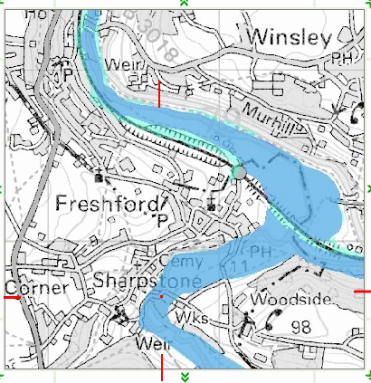
These photographs show quite clearly that the Flood Maps used by Department of the Environment mislead the public by locating the Freshford Mill site much higher up the valley than it actually is.I have been reassured by the Ordnance Survey that the error will be corrected with the next issue of the 1:50000 map
|
|
|
|
The Freshford Mill site is in the blue area of the map ie. it is much more at risk of flooding than would appear from the flood risk map. The red crosshairs identify the actual location of the mill boundary allowing for scale.Although as mentioned elsewhere DEFRA has assured me that the maps used by BANES planning are correct there is even room for doubt for the accuracy of Ordnance survey maps in general. Contours may be out by as much as 30m in height! http://waterconsultant.com/
|
