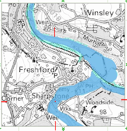
Flood Risk3.13 Freshford Mill lies wholly within the floodplain of the River Frome (as shown on the Deposit Draft Proposals Map, Inset 35 (CD A2.1.5)). Floodplain maps are regularly updated by the Environment Agency and in the current maps the whole of the main block of buildings on the site lie within a zone 3 floodplain (i.e. areas most at risk from flooding) as shown on the map attached as Annex 2. Whilst policy NE.14 of the Revised Deposit Draft Local Plan (RDDLP) (CD A2.1.10) allows for development within areas of flood risk where the flood hazard can be mitigated or other circumstances apply, the Council do not consider it appropriate to allocate a site for mixed use development that lies within an undefended zone 3 floodplain. This accords with the precautionary approach set out in PPG25: Development and Flood Risk (CD A1.1.25), particularly in relation to proposed residential development. The flood risk extends all along the Frome and Avon valleys. In fact Bath has a very large area of buildings and land that are at great risk. This page includes photos of the bridge at Freshford Mill
To view another Environmental Agency map of the settlements that are at risk of flooding click here View: DEFRA post code maps
Photographs of the road junctions serving Freshford Mill. The red dot roughly locates the existing
Freshford Mill site entrance. If this information was used by the Environment Agency to guide BANES Planning Department when they made their decision to recommend to the Council to approve Suttons' proposal for the Freshford Mill site then they should be instructed to reconsider their advice. (the Environment Agency have checked this information and assure me that, although there is an error in the Ordnance Survey map the maps used by Planning were accurate) The Ordnance Survey promised to correct the map and although they have altered the legend "Wks" to "Mill" the location of the mill has still not been corrected. The flood risk assessment is also subject to global warming the Greenland ice is now been found to be melting at twice the rate -this will affect the sea level (BBC News 17th Feb 06) Maps in general can be misleading as the road thickness needs to actually register on the map. The width of the flooded land where the river Frome meets the river Avon is nearly half a kilometre wide! Also, the map shows quite clearly that the Bristol- Weymouth railway line, even though its on an embankment, is under threat. How will this Flood Risk map change if the capacity of the flood plain to hold flood water were to be altered by any attempt to divert water away from the Freshford Mill site? could the railway collapse? Would the ancient Inn at Freshford (photo) be severely damaged? Recent Photo (December 2007) Flooded and iced field: photo icy flood |
 The legend "Wks" located at the junction of the lanes is misleading. This
error is on the OS 1:50 000 mapping but not on 1:25 000 maps
The legend "Wks" located at the junction of the lanes is misleading. This
error is on the OS 1:50 000 mapping but not on 1:25 000 maps